
In 2012 I surprised myself by splashing out on a second-hand Leica 1250 GPS system, which enables me to emulate some of the activities of the tamperers. I do not have a level and staff, or the same levels of patience and dedication, or a faithful border tamperer to carry equipment and film the proceedings. Nor do I have the expensive software to process the raw survey data. Scoop John B kindly offered to run the software if I supplied him with the data, which produces highly accurate measurements but has the disadvantage that I have to wait a while after the survey to find out the results, which diminishes the excitement somewhat.
Results of the hill surveys I carried out last year are summarised below, with the focus on marginal Sims and Submarilyns, plus the occasional Subhump, all in Scotland. Without the equipment or expertise of the tamperers, I tried a more lightweight one-man operation. This meant that I could not always identify the precise position of a col (and sometimes a summit) to set up the GPS and collect the satellite data. I tried to compensate for this by carrying out a survey in two, or occasionally three, different nearby locations, so that I could be reasonably confident that one of them was the actual col (or summit).
This meant shorter survey times, of 30-90 minutes, rather than the two hours or more commonly used by the tamperers and required for Ordnance Survey validation. I was more concerned with fitting the surveys into bagging trips than with external validation, so on some occasions I was able to leave the equipment at a col to go and bag a summit, though this did not work very well if I wanted to survey the summit too. These methods mean there is a slightly greater margin for error than in surveys by the tamperers, so I only quote figures to the nearest 10cm. Even this is far more accurate than any data from large-scale maps or any other source.
The most difficult hills to survey were Aonach Beag, where both summit and col were under several inches of snow, Leum Uilleim, where the enormous cairn made it difficult to locate the highest natural ground (it turned out to be a small rock 20 metres west of the cairn), and Marg na Craige, where the sprawling col made it almost impossible to locate the right survey point with any certainty, so the margin for error was a relatively huge ±0.5m. However, even this was enough to confirm that the drop is very unlikely to be as much as 150m.
My overall response to these surveys was a mixture of disappointment and satisfaction. It was disappointing that none of the Submarilyns were promoted, and only one Subsim (Meall Reamhar North Top, formerly Creag Mac Ranaich point 616m), yet satisfying that my original findings derived from maps turned out to be remarkably accurate in most cases.
One survey produced unreliable results which were discarded owing to equipment malfunction (the pole blew over in the high wind while I was away on a route recce). The Cairnie Hill col was also very difficult to survey with my methods, the col being alongside the railway line with thick tree cover either side of the track. This hill was also surveyed by the tamperers at the same time, who were able to set up their GPS in a clearer location and use levelling to work out the actual col height. In fact there was very close correlation between the two sets of measurements at both summit and col, which was reassuring, but it did confirm that it would not be possible for me to survey tree-covered summits or cols with my current methods. However, this still leaves plenty of hills on my hit list, so I hope to carry out more surveys in 2013. Results will be summarised at www.rhb.org.uk/reports as well as in Marhofn in due course.
As well as the survey results reported here and by John Barnard, some further changes derived from extensive study of large-scale online maps by the Hills Database team, particularly Jim Bloomer, which have led to one new Submarilyn and one more new Sim:
| 10A | Sgurr Mor Far West Top | 600 | c35 | NG869082 | New Sim |
| 28B | Moneylaws Hill | 246 | 140 | NT872347 | New Submarilyn |
With the addition of Meall Reamhar North Top but the demotion of Meallan Liath, this takes the current number of Sims up to 2532. The Sim Hall of Fame continues to stay out of reach of most baggers, with just two new entrants during 2012, leaving the table looking like this:
| Ken Whyte | 2532 |
| Iain Thow | 2389 |
| Colin Crawford | 2288 |
| Andy Hyams | 2195 |
| Rob Woodall | 2021 |
I hope to join them in two or three year's time, fitness and will permitting.
| Section | Hill | Height | Drop | Grid reference | Outcome |
| 1B | Beinn Each North Top | 704.0 | 27.4 | NN601163 | Confirmed as Subsim, drop less than 30m |
| 1C | Am Fireach | 712.9 | 30.7 | NN561125 | Confirmed as Sim, drop over 30m |
| 1C | Meall Reamhar | 670.5 | 99.2 | NN569247 | Confirmed as Subhump |
| 1C | Meall Reamhar North Top | 619.2 | 31.8 | NN562257 | New Sim, drop increased from 28m |
| 4A | Leum Uilleim | 906.4 | 497 | NN331641 | Height measured, 909m on maps refers to cairn |
| 4A | Leum Uilleim South Top | 847.2 | 32.5 | NN332633 | Confirmed as Sim, drop over 30m |
| 4B | Aonach Beag | 1115.7 | 99.0 | NN458742 | Confirmed as Subhump and not a New Munro |
| 4B | Beinn Eibhinn | 1103.2 | 127 | NN450733 | East top is summit, at NN 44965 73302 |
| 4B | Beinn a'Chumhainn | 901.9 | 145.4 | NN463710 | Confirmed as Submarilyn and New Munro |
| 4B | Meall a'Bhealaich | 865.2 | 97.4 | NN452695 | Confirmed as Subhump |
| 4B | Meall na Duibhe | 571.3 | 149.1 | NN227623 | Confirmed as Submarilyn |
| 9B | Marg na Craige | 833.5 | 149.1 | NN621973 | Confirmed as Submarilyn |
| 9B | Beinn a'Chrasgain | 826.6 | 62 | NN606981 | Confirmed as lower than Marg na Craige |
| 16B | Meallan Liath | 599.7 | 147.4 | NC515504 | Confirmed as Submarilyn, deleted Sim |
| 16B | Ben Screavie | 333.0 | 145.8 | NC309394 | Confirmed as Submarilyn |
| 16E | Sail na Slataich | 652.1 | 29.8 | NC314305 | Confirmed as Subsim, drop less than 30m |
| 16E | Spidean Coinich East Top | 620.7 | 29.4 | NC211273 | Confirmed as Subsim, drop less than 30m |
| 26 | Cairnie Hill | 228.8 | 150.3 | NO279159 | Confirmed as Marilyn |
| 28B | Middle Hill | 717.1 | 42 | NT159295 | Height and drop confirmed |
| 28B | Grey Weather Law | 712.0 | 25 | NT169301 | Confirmed as Subsim, col location moved |
| 28B | Taberon Law | 636.7 | 28.6 | NT146289 | Confirmed as Subsim, drop less than 30m |
| 28B | Fastheugh Hill | 501.5 | 144.9 | NT393276 | Confirmed as Submarilyn |
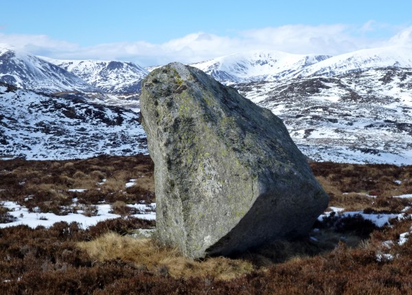
This tricky boulder stands about 2.5m high on top of a summit that may or may not be a new Sim. It's listed in the Hills Database as 601m high, drop 27m, but that does not include the boulder. After four failures I finally managed to slither up it from the other side (which is easier) by taking off my boots and getting a grip with my socks, so it would be not be easy to get a GPS up there and balance it on the top. I may need help to survey this one. The hills shown to the north are the Beinn a'Ghlo group, and you may need a G'n'T to help you up it.
