
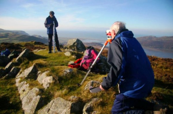
In 2012 there was one change to the list of Marilyns. In September we surveyed the double-topped Corbett Buidhe Bheinn/Sgurr a'Bhac Chaolais, with the Scottish Mountaineering Club (SMC). Which of the two points is the higher had been the subject of debate for a long time. The Ordnance Survey had not resolved this either on their most recent maps, and they had placed 885m spot heights on each hill. We used two Leica GPS units collecting data simultaneously on these two hills, which is one of the most accurate ways to measure a height difference. Our measurements, confirmed by the OS who also processed the data, showed that Buidhe Bheinn is the higher by 0.29m. So, all those out there, including myself, who have not climbed Buidhe Bheinn, I am afraid it is one less Marilyn. I drew the short straw on the survey and stayed with the GPS collecting data on Sgurr a'Bhac Chaolais. The result has also been accepted by the SMC for the correct location of the Corbett.
At the same time as this survey, we heard from the SMC that they had accepted the results of our survey carried out in 2011 of Beinn a'Chlaidheimh which just failed to reach 3000ft and hence Munro status, thereby converting the Fisherfield Six into the Fisherfield Five.
Tampering in action
We continued our programme of heightings with The Munro Society and surveyed two of the remaining highest Corbetts; Leathad an Taobhain and Beinn Bhreac, as part of the search for a new Munro. Unfortunately, neither of these hills reached the required 914.4m and our measurements just confirmed the map spot heights. A problem that had bugged us for some time was the Corbett, An Dun. This has two tops, north and south, and there has never been a definitive measurement to identify the higher. In fact, over the years the summit has swapped back and forth. We tried several years ago with Abney levels to resolve the issue but realised these instruments did not have sufficient resolution to do the job. So we carried all the gear from the main road to the south, identified the highest points on the north and south tops and then line-surveyed back and forth between them. The result, which was most disappointing, was that we cannot be sure. We measured a height difference of 0.03m, with the two measurements agreeing to within 0.005m. However, the variation in ground height around the cairns was at least as great as the measured height difference, so we felt it incorrect to make a statement that one top was clearly higher than the other. So that is the best we can do. The OS accepted the result and 827m appears as a spot height on each top.
Not much else in Scotland for us, but we took the opportunity on a walking weekend in the Cairngorms to locate the summit Tom Dubh that Irvine Butterfield described as '...the most meaningless 3000foot top in all Britain...'. On two previous occasions, I had wandered around the summit plateau visiting all possible contenders. Now we have the highest point, however, those who want to go there will need to use the ten-figure GR in their GPS to find the correct position.
In England and Wales, we have identified two new Humps, Pared y Cefn-hir and Gowbarrow Fell. Michael Dewey's list of P30 500m hills did not fare so well. Surveys deleted Watch Hill and Little Fell from the list due to insufficient drop. In addition, the armchair surveyors deleted another two from map evidence for insufficient drop. All the remaining surveys that we carried out resulted in identification of a summit position or confirmation of the hill's status, and are listed in the table below.
2012 also saw a change to the equipment we use. Since 2008 we have been using a Leica 530 GPS for absolute height measurements. In late 2012 the unit developed a fault on the power circuit boards which meant we could not use it with the on-board batteries.
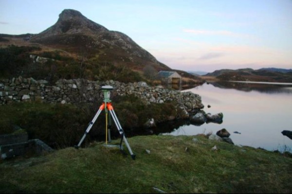
Leica Viva GS15 on Pared y Cefn-hir (photo: GJ Surveys)
Unfortunately this unit is now not serviceable and spares not available. Therefore, we have invested in the latest Leica GPS; the Viva GS15 Professional Unit. Apart from working, this has a number of advantages, particularly in terms of being half the weight of the 530, just what our increasing age demands. From the measurement point of view it can also receive data from the GLONASS satellite system (the Russian ones are up there already) and is future-proof to collect data from GALILEO when the European Space Agency stop debating and launch enough satellites to get the system working. However, all is not lost with the Leica 530 since it can still be operated with an external power supply called a brick because it is the size of one, weighs the same as one and is red. We feel this solution is on borrowed time, but it has given us the opportunity to carry out tests on different equipment for comparison, and also to use two GPS machines simultaneously to measure accurately height differences. We keep fingers crossed that the 530 will go on for some time, but we are not confident.
| Section | Name | Height | Drop | Summit | Status |
| 5 | An Dun | 827 827 | 232 5 |
NN71738049 NN71658013 |
North and south tops are equal height to within 0.03m |
| 6A | Leathad an Taobhain | 911.7 | 155 | NN82178582 | Confirmed Corbett |
| 6A | Beinn Bhreac | 912.4 | 524 | NN86848206 | Confirmed Corbett |
| 8 | Tom Dubh | 918 | 40 | NN92149527 | Summit position located |
| 10A | Buidhe Bheinn | 885.5 | 163 | NG96330904 | New Corbett/Marilyn |
| 10A | Sgurr a'Bhac Chaolais | 885.2 | 121 | NG95831102 | Deleted Corbett/Marilyn |
| 26A | Cairnie Hill | 228.9 | 150.3 | NO27931548 | Confirmed Marilyn |
| 30C | Moel y Waun | 411.9 | 99.1 | SJ16845343 | Confirmed SubhuMP |
| 30C | Moel yr Accre | 411.3 | SJ16955266 | Unclassified - lower than Moel y Waun | |
| 30E | Lledwyn Mawr | 526.0 | 30.9 | SH90502874 | Confirmed Dewey |
| 30F | Pared y Cefn-hir | 383.0 | 149.4 | SH66191488 | New Hump/Submarilyn |
| 30F | Bryn Brith | 382.9 | 40 | SH66451536 | Deleted Hump/Submarilyn |
| 31B | Stanky Hill | 506.6 | 30.3 | SO16397642 | Confirmed Dewey |
| 34C | Gowbarrow Fell | 481.2 | 100.1 | NY40732172 | New Hump |
| 35A | Benty Hill | 609.2 | 28.1 | NY66934304 | Confirmed Subdewey |
| 35A | Watch Hill | 603 | 29.0 | NY62494603 | Deleted Dewey |
| 35A | Wild Boar Fell | 708 | 344 | SD75809879 | Summit location |
| 35A | Little Fell | 559 | 28.8 | NY76640099 | Deleted Dewey |
| 35A | Great Knipe | 514.9 | 66 | NY86751445 | Summit location |
| 35B | Horse Head Moor | 609.3 | 31 | SD89437697 | Confirmed Dewey on height only |
| 36 | Blackstone Edge | 474 | 102 | SD97331626 | Summit location |
Follow GJ Surveys on Facebook at www.facebook.com/gj.surveys

Ceramic Buidhe Bheinn and Sgurr a'Bhac Chaolais, if sea level rose 735m (Charles Everett)
