
When the word 'Moffat' appears in Marhofn, it is usually in the HoF listings after my name, under the 'Home' column. So when I spied the name of my adopted home amongst the general text of last year's tome, my eye stopped scanning and I read in depth. When we relocated to live in Scotland, now nearly eight years ago, it never entered my head that I would still be living in the southern half of Britain. On moving north of the border in 2002, Beryl and I lived in Dumfries for a year before moving to a rural location in the Moffat hills. According to Thomas Murray's analysis in Marhofn 196, the centre point of Britain is close to Moffat, at NT 0860 0850. If he is correct, then my Dumfries abode was actually in southern Britain, but my present (and final) home is just in the northern half of Britain. It would indeed be of interest to quite a few Scots to learn that a part of their country lies in the southern half of Britain. I doubt that it would go down too well in the ale-houses of Dumfries or Lockerbie, or in Moffat itself, as on this basis it lies in the south as well.
Not often seeing the need to question the Ordnance Survey's mapping and conclusions on all things cartographical, I had always assumed that the centre of the kingdom was in the Forest of Bowland at SD 64188 56541. Even this would astonish many a cockney, to be told that the centre of Britain resided in 'up north' Lancashire. (Rather like the Christian Church in the pre-Galileon era, which had dogmatic views on the earth/sun relationship, many Londoners believe that the rather inconsequential 'provinces' - the entire UK outwith the capital - revolves around their city, the heart and centre of the British universe.)
Always liking to have a theme or focal point when on a walk (this is probably why I enjoy peak-bagging so much, to provide a framework for an adventure into the hills), I showed great enthusiasm for the venture when, a few years back, friend and Corridor member Jeff Parr suggested that we base a day's outing on a walk to the Forest of Bowland's 'centre of Great Britain and its 401 associated islands'. Jeff, as a Lancastrian, was proud to lead me to the OS-designated centre point, buried deep in the moors of his home county. Perhaps not surprisingly, although the walk itself was a very fine one, in glorious country, the 'centre', when we finally located it with the help of our GPS units, was far from inspiring. Such things in life often are. However, when learning last year that Lancashire had been moved far down into the deep south, and that the Moffat area had become nationally famous overnight, I was keen to reciprocate with Jeff, so I invited him on our second 'Centre of Britain walk'. I had in fact undertaken the majority of this walk on several previous occasions, although I had not actually before made the 200-metre detour from the sensible line of my route to seek out the centre point. I had some concern that the actual centre would lie in the middle of an impenetrable forestry plantation, but all was well, as the GPS told us that the magic spot lies in a small clearing in the trees. And was it worth the effort? Was it hell as like! But then how many other people have visited both 'centres of Britain'? There may be thousands of Munroists and even a handful of people who have more than 1500 Marilyns to their name, but who else can claim a 'double centre' completion? Fame at last.
If anyone is interested in repeating our venture, then I can most certainly recommend our walk, if not a visit to the actual centre itself. From the free central car park in Moffat, head north up Well Street (the second-hand bookshop is worth a look) and onto the path into the woodland on Gallow Hill, then continue north for a little over a mile to locate Britain's centre. A relatively gentle low-level circuit can be made by returning to Moffat from Ericstane Farm and finishing with the riverside path along the Annan back to Station Park.
Those wanting a longer day and to bag 808m Hart Fell after visiting the 'centre', can easily do so by heading into the hills to the north-east over Arthur's Seat.
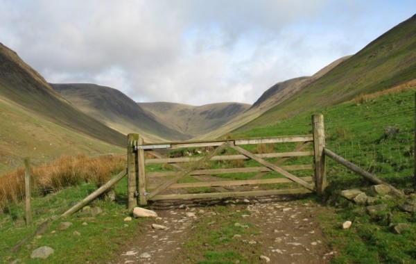
Blackhope Valley and Hart Fell (photo: Alan Castle)
If Thomas is correct with his calculations then I live approximately two minutes of latitude north of the centre of Britain (just over a couple of miles to you and me). Hence I am proud to announce to the Marilyn world that of all the HoF members, I am the one who resides closest to the centre point of Britain. Moreover, my local Marilyn, the very fine Corbett of Hart Fell, must also be lying up there feeling quite conceited with the fact that it lies closer to the centre than any of the other 1555 other Marilyns (or is it now 1554 others - it is so difficult to keep count in these rapidly changing days). Though perhaps Hart Fell is rather miffed that Dungavel Hill, a mere satellite of Tinto, gets the accolade of the most central Marilyn of Britain. All these calculations are a bit over the head of this mathematical ignoramus, so I hope that I haven't made some awful bloomer in these assumptions - if I have, then knowing what a bunch of pedants Marilyn baggers tend to be, I am sure that I will be put right in next year's Marhofn!
