
Graham Bunn: Had a look from the south, but no parking and no welcome, so we went to the north and parked where a track goes to the windfarm and a road goes to Carrot. Took signed path across field and onto forest track. Just after Dickman's Glen a padlocked gate was encountered. Signs had been removed; we noticed one thrown in long grass 'Keep Out - Construction Site'. We continued along the track, which stops at some boulders and a track for a new windfarm. The site is a hideous mess. The track marked on the map is no longer there. We followed windfarm tracks around to the trig point, which is next to a building with generators. At present the whole area is an eyesore, but when the windfarm is constructed it may give access from the road to the east.
Tom Waghorn: The summit is a ruined concrete monstrosity, with a rusting cooking range, from wartime RAF radar days.
Alan Dawson: A lovely island, reached by a brilliant flight, with wonderful cliffs and coastal scenery. The summit is a rubbish dump of large ugly concrete blocks, apparently the result of the destruction of wartime relics so that they would not detract from a fleeting royal visit 48 years ago. As Eric Young succinctly put it, the island residents have been trying to decide what to do about the resulting mess ever since, and don't want to be rushed into a decision.
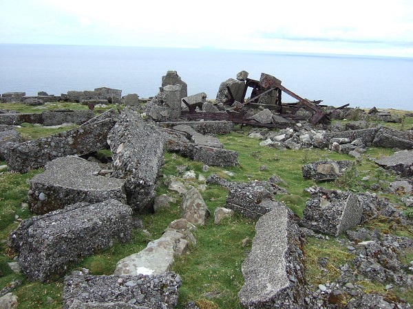
Some of the concrete junk on top of Ward Hill (photo: Alan Dawson)
Jon Metcalf: Which do you hate most, the bogs of north Lewis, the tussocks of Jura or those scattered heather nightmares (Newtyle Hill, Bainloch Hill, Binnean nan Gobhar, Dirrington Great Law, Thorpe Fell Top)? Jura probably provides the lowest bottom feeders out of the 1554 hills for me, but Cairnsmore is a hill to direct your non-masochistic friends away from. Dave Hewitt loved it of course.
Graham Bunn: Whilst not on the usual route to the Marilyn, this is relevant if doing an extended walk. We did Roseberry Topping and Easby Moor and were returning toward Highcliff Nab via Gribdale Gate and Percy Cross Rigg. While on the public footpath to Highcliffe Farm we saw a Land Rover drive down the moor, and a youngish man got out to meet us. He informed us that there wasn't a path here and we were scaring ducks and partridge. I agreed that there wasn't a path on the ground, but he didn't understand the principle of a right of way, even when shown the map. He eventually left us to wade through to the Cleveland Way, as he went off to chase after another walker on Codhill Heights, which is also on access land. We reported the incident at the information centre in Pinchinthorpe. The warden there said that a number of access problems have been encountered in Sleddale, which is the dale to the west of Gisborough Moor.
