
In Marhofn 171 I wrote an article in which I outlined how Graham Jackson and I had become interested in the esoteric hobby of hill surveying, with a summary of the equipment we were using and the main results we had obtained during 2006. The hobby did not die in 2007 but moved on with even greater enthusiasm, and we were joined by others on our surveying expeditions, notably Myrddyn Phillips. 2008 is also looking to be a very busy year and the in-tray of 'work' seems to be piling up, even without needing to cross the border into Scotland.
So what did we do in 2007? We added additional equipment, including a more accurate automatic level, that enabled us to increase the range of surveying problems we can handle. We carried out a number of detailed surveys that greatly increased our experience and led to improved techniques and greater accuracy in our work; reports have been posted in the files section of the RHB Yahoo group. Contact has been established with the Ordnance Survey, who have used some of our data to make changes for future editions of their maps. John and Anne Nuttall, and Michael Dewey, have accepted the results from the relevant surveys and have altered their hill lists accordingly. In addition to all this, four of us now take our Abney levels on the hills, enabling us to pinpoint most summits and obtain GPS 10-figure grid references to be fed into the hills database at www.biber.fsnet.co.uk. For the future, we have been evaluating additional equipment that will enable us to extend our surveys and perhaps measure some of the SubMarilyns.
In 2006 our surveys focused on hills where the problem was to identify the exact position of the summit, usually from two contenders several hundred metres apart but very close in altitude. The technique was simple as it required observing one contender from the other and making a decision about which is the higher. By taking several measurements and using digital photographs, taken through the level, we were also able to quantify the height differences. However, this technique does not work well if the height differences are greater than a few metres, and of course one must be able to see one point from the other.
The conventional way of surveying with an automatic level is to use it in conjunction with a calibrated staff; this is called differential levelling. The technique is pretty basic and is described in detail in surveying textbooks and on numerous websites. Although it is simple, it is actually a very accurate way to measure height differences in the hills. Since we had no experience of this technique, we decided at first to focus on hills over 600m high with 15m of ascent from the col or bwlch to summit; the Nuttalls.
As with most things in life we found quite quickly that there is nothing like practical experience for enabling improvement. We would come back from the initial surveys and be able to think of new tweaks to improve accuracy. I hope anyone who has read our reports will have noticed this improved quality as we have gained experience. I think we now know how to squeeze the maximum accuracy out of the equipment. In fact, the limits on determining accuracy are often related to factors on the ground; for example, the error in finding the exact location of a bwlch or bealach.
As we became more experienced we started to survey 'dodgy Deweys', where the required reascent of 30m is double that of a Nuttall. The main conclusions for 2007 were:
Castell y Gwynt proved an interesting hill to survey. Being a pile of rocks it is too steep to survey with an automatic level and staff, so we had to survey it trigonometrically. This was done using a new piece of kit called a Leica Disto A8 - a laser measuring device that can measure both angles and distances.
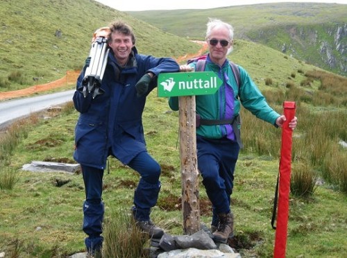
Graham Jackson (left) and John Barnard, having just established Y Fronllwyd to be a new Nuttall
So what are we going to do in 2008? There are more surveys to be carried out to check borderline Deweys and Nuttalls. However, it would be great to be able to tackle some SubMarilyns to check on the 150m of reascent. This does pose a bit of a problem for the differential levelling technique. It takes about ten minutes to set up and take the forward and backward measurements that are required to measure a drop of 3m to 4m. This means of the order of 40 to 50 sets of readings for a SubMarilyn, so a one-way survey from col to summit will take seven to eight hours. A full two-way survey, to establish the closing error and be confident about the result, is essentially a two-day job. (Even I'm not sure if I could be bothered to hold a staff vertical for two days.) Therefore, if we want to survey this category of hill we will probably be forced into a combination of differential line surveying and trigonometric surveying. The latter will require the purchase of a theodolite (we cannot afford the £20000 required for a Leica Smartrover GPS set). Good second-hand optical theodolites are available, but it is not the price that worries me so much as the weight to carry in a rucksack; a minimum of 4.5kg excluding all the other bits of equipment. Perhaps this year's birthday present will be a mule and a horse-box - I've got the tow bar and number plate already.
Mark Jackson has compiled a 150-page ebook listing all 2994 British hills with Hundred Metre Prominence (Humps) in RHB format. This draws on work by Eric Yeaman, Rob Woodall, Clem Clements and others. It is available for download from the RHB newsgroup in PDF (with maps) and plain text format, along with Mark's regional listings of hills with 30m prominence (relative height). So far he is up to 7082 hills and still going.
'Ordnance Survey maps in all their shapes and sizes are the most beautiful manifestation of twentieth-century British functional design'
Bill Drummond, 45
